Margate Back-Bay Dredging Program Moves Forward
Margate prepares for a major back-bay project
Margate is preparing to begin a citywide canal dredging program in mid-September 2026, addressing a problem that is easy to overlook from land: constantly shifting sediment in the city’s back-bay waterways.
The project follows an unusually long regulatory process. According to the research packet, the permitting framework required eight years of regulatory clearance.
One significant component allows private riparian property owners to coordinate dredging of their individual boat berths while municipal navigation channels are being addressed.
For Margate’s waterfront community, the project involves both routine navigation and the larger challenge of managing waterways that continually change.
Why does Margate need canal dredging?
Back-bay waterways are dynamic environments.
Sediment moves through channels, mudflats shift, marsh boundaries change, and shoaling can gradually reduce navigable water depth.
Those conditions affect recreational boaters, but they can also affect emergency vessels that need dependable access through local waterways.
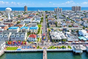
Sustainable Margate recently joined municipal officials and environmental coordinators for field observations aboard the Capt. Robin. The group evaluated changing mudflats, saltmarsh boundaries, and sedge islands in the back bay.
Those observations help illustrate why dredging cannot be viewed simply as removing material from one fixed channel. The waterways themselves continue to evolve.
Private boat slips can be coordinated with city work
One of the notable aspects of Margate’s dredging framework involves private waterfront property owners.
Under the municipal permitting arrangement described in the research packet, riparian owners can dredge private boat berths while the city addresses its navigation channels.
That coordination can be important because a clear municipal channel does not necessarily solve access problems if sediment has accumulated around a private berth.
For participating owners, aligning private work with the larger dredging program creates an opportunity to address both sides of the access issue within the permitted framework.
Property owners should still rely on the applicable municipal process for the specific requirements affecting their property.
Eight years of regulatory clearance
Coastal dredging projects can involve complex environmental and regulatory considerations, and Margate’s experience illustrates that reality.
The permitting framework behind this program took eight years to clear.
That timeline reflects the complexity of working in sensitive back-bay environments where navigation, private waterfront access, sediment management, and ecological conditions intersect.
It also explains why the start of physical dredging represents a meaningful milestone.
The visible work may occur over a relatively defined period, but the administrative process required to make it possible began years earlier.
What the Capt. Robin survey found
The Sustainable Margate back-bay field survey focused on physical changes occurring throughout the waterway system.
Officials and environmental coordinators observed:
Shifting mudflats
Changing saltmarsh boundaries
Dynamic sedge islands
Sediment movement affecting navigation
These are not merely cosmetic changes.
Rapid sediment migration can create hazards for vessels, including emergency watercraft that need reliable access through local channels.
That makes back-bay management part of Margate’s broader infrastructure and resiliency picture alongside oceanfront beach protection, drainage, and other coastal systems.
Why waterfront homeowners should pay attention
For Margate waterfront property owners, usable water access is an important physical characteristic of a property.
Dredging conditions, private berth depth, municipal channel access, and permitting requirements can all become relevant when maintaining or evaluating a waterfront home.
Those factors are property-specific and should not be generalized across every bayfront or lagoon location.
For buyers, understanding the difference between simply owning waterfront property and having practical navigable access is an important part of due diligence.
For sellers, being able to clearly explain the property's existing water access and relevant improvements can help buyers understand what they are purchasing.
If you're evaluating a Margate waterfront property and want help understanding how its location and water-access characteristics compare with other local homes, contact Lexy Realty Group → https://www.lexyrealtygroup.com/contact
Quick FAQ
When is Margate’s dredging expected to begin?
The citywide canal dredging program was scheduled to begin in mid-September 2026.
Can private property owners dredge their boat slips?
The research packet states that private riparian owners can coordinate private boat-berth dredging under the specialized municipal permitting framework.
Why is sediment movement a concern?
Shoaling and changing back-bay conditions can impede recreational navigation and create hazards for emergency vessels.
Sources: Downbeach Today